

Katherine
Top End
The Victoria River's escarpment country is the NT's 'mini Kimberley' — dramatic gorge cliffs, boabs and cattle-station history most travellers only ever see through a windscreen.
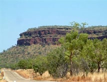
For most travellers between Katherine and the Western Australian border, the Victoria River is a ten–minute event: the highway drops off a plateau, the windscreen fills with red sandstone cliffs standing over a wide green river flat, and then the road climbs back out the other side and the moment is gone. It is, by common agreement among people who drive the Victoria Highway for a living, one of the great drive–through landscapes in the Top End — a slab of country the Kimberley tourism machine over the border would be thrilled to own, sitting instead almost entirely on the Northern Territory side and largely unbothered by anyone who does not already know to stop. The river itself is the Territory's largest, and the gorge–and–escarpment district it has carved is the reason locals have called this the "mini Kimberley" for as long as anyone can remember saying it.
Our writer Fiona pulled off the highway at Victoria River Crossing on a clear June morning, meaning to fuel up and keep driving towards Kununurra by lunch. She did not leave until the next afternoon. That is the honest pitch for this stretch of the Territory: it rewards the traveller prepared to be delayed, and it does not punish anyone who isn't — the highway keeps rolling regardless of who stops. But pull over, even for an hour, and the country stops being scenery glimpsed at 110 kilometres an hour and starts being a place in its own right.
The Victoria River district is the country of the Ngaliwurru, Nungali and Ngarinyman peoples, whose traditional lands run along the river and its tributaries through the escarpment ranges around Timber Creek and out towards the Western Australian border. Neighbouring groups hold country further down the system towards the coast. This has been occupied and managed country for tens of thousands of years, and the rock art sites tucked into the sandstone galleries of the district — including a significant gallery on the Joe Creek walk in Gregory National Park — are still actively cared for by traditional owners working alongside park rangers.
The river itself is worth pausing on. At roughly 560 kilometres from its headwaters in the Stokes Range to Joseph Bonaparte Gulf, it carries the largest catchment of any river system in the Northern Territory, and in a big wet season the volume moving through the gorge country is genuinely startling — the high–water debris caught in trees well above the dry–season channel is usually the first clue for first–time visitors of just how much water passes through here between December and March. That flow is what built the boab–studded floodplains and cut the sandstone escarpment that makes this district look so unlike the flat woodland either side of it.
Victoria River Crossing, where the Victoria Highway bridges the river, is arguably the single most photographed roadside stop in the Top End, and it earns the reputation honestly. The Victoria River Roadhouse sits right at the crossing under a stand of boabs, and the view from the bridge and the lookout beside it — tiered red escarpment walls stacked above the river flat, more boabs scattered through the grass, the whole scene doubling in the water at the right time of day — is the kind of vista that makes people who were planning to drive straight through pull the car onto the verge instead.
Sunset and early morning are the times to be there. The low light rakes across the escarpment face and turns the sandstone from rust to something closer to burgundy, and the roadhouse verandah is, unglamorously, one of the better sunset seats in the Territory. It is also simply a useful stop — fuel, food, basic accommodation and a caravan park make it the natural overnight base for exploring the district, whether you are heading into Gregory National Park or continuing on towards Timber Creek and the border.
Gregory National Park is one of the largest protected areas in the Northern Territory, and it covers much of the escarpment and gorge country either side of the highway in two separate sections. The northern section, closest to Victoria River Crossing, holds the short, steep Escarpment Walk, which climbs to a lookout over the river and the surrounding cliff country and is worth the sweat for the view alone, and the Joe Creek walk, a longer loop past a rock art gallery set into the base of the escarpment.
The park's southern section, reached via unsealed roads off the highway, is built around the Bullita homestead ruins — the remains of an old pastoral outstation, complete with stockyards, that is one of the better surviving windows onto the district's cattle history. From Bullita, high–clearance 4WD visitors can tackle the Humbert Track and Wickham Track, remote, boab–lined routes through some of the wildest country the park holds. These are genuinely remote drives — no fuel, no phone signal, and dry–season access only — and anyone planning to run them should check current conditions and permit requirements through Parks and Wildlife NT before setting off, not after.
Timber Creek, the district's small service township, sits around 90 kilometres west of Victoria River Crossing on the way towards the WA border. It punches well above its size historically. Just outside town, the Gregory's Tree Historical Reserve preserves a boab carved by Augustus Gregory's North Australian Exploring Expedition, which based itself here in 1855 and 1856 — among the earliest European incursions into this part of the Territory. Decades later, as pastoral leases pushed west through the district, a police post and telegraph link were established at Timber Creek in the 1890s, making it one of the oldest continuously significant non–Aboriginal settlement points in the Northern Territory, even if it never sat on the main Overland Telegraph Line further east.
Today Timber Creek is unassuming — a pub, a store, fuel, a caravan park and a boat ramp — but it remains the practical hub for the whole district, the last decent stop before the WA border and the jump–off point for river cruises that run out onto the Victoria in the dry season. The old cemetery and the handful of interpretive signs around town are worth twenty minutes if you have them; the history here is understated but real.
This is cattle country before it is anything else, and has been since the 1880s. Victoria River Downs — universally known simply as "the Downs" or "VRD" in stockman shorthand — was taken up in 1883 and grew, under a succession of owners including the British Vestey pastoral empire, into one of the largest cattle stations in the world, at its peak running over a million hectares. Stock from VRD and the surrounding leases were droved overland for decades to meatworks and ports, and the district's stock routes, yards and homestead ruins — Bullita among them — are physical remnants of that era. The Victoria River District is fairly described as one of the birthplaces of the Northern Territory's beef industry, and the working stations, road trains and mustering camps you pass on the highway today are a direct continuation of it, not a heritage re–enactment.
The Victoria River holds serious barramundi, and the lower reaches in particular attract fishers chasing them through the dry season. It is also, without exception, heavily populated saltwater crocodile habitat, and the same rules apply here as everywhere else in the NT's northern river systems: stay well back from the water's edge, never wade or swim, launch and retrieve boats only at formed ramps, and do not assume a stretch of bank is safe because it looked clear five minutes ago. Crocodiles move, and the Victoria's murky, tidally influenced water makes them harder to spot than in clearer systems further east. Check current advice and any recreational fishing rules through NT Fisheries before you wet a line.
The whole district sits directly on the Victoria Highway, the sealed link between Katherine and Kununurra in Western Australia, so almost every overland traveller doing the Darwin–to–Broome run passes through whether they mean to stop or not. From Katherine, Victoria River Crossing is around 195 kilometres west; Timber Creek is a further 90 kilometres on; and the Western Australian border, with Kununurra not far beyond it, is roughly another 215 kilometres past that — call it 500 kilometres end to end from Katherine to Kununurra. From Darwin, allow around 500 kilometres just to reach Victoria River Crossing, so most visitors treat it as a stop within a longer Top End loop rather than a standalone day trip. The highway itself is sealed and well maintained; it is the side roads into Gregory National Park that demand a proper vehicle.
The dry season, roughly May to October, is when this district works properly. The highway stays open year–round, but the unsealed access roads into Gregory National Park's Bullita section, and the Humbert and Wickham tracks in particular, are dry–season only and close at the first serious wet–season rain. June through August offers the most reliable combination of cool mornings, warm clear days and full access to the park's walking tracks and 4WD routes.
November through April is a different district altogether. The Victoria River floods hard, the escarpment country gets cut off from the unsealed side, and humidity and storm activity build through the build–up months. The highway generally stays passable, since it is sealed and built above most flood levels, but check current conditions before travelling in the shoulder months either side of the wet, and keep an eye on the Bureau of Meteorology's Northern Territory forecasts and river height information if you are travelling October to April.
The Victoria River district's problem, if it has one, is that it looks like a place to drive through rather than a place to stop, and the highway is engineered well enough that you can do sixty kilometres an hour past some of the best scenery in the Top End without really registering it. Fiona's honest verdict, delivered from the Victoria River Roadhouse verandah with the escarpment going red behind her, was that she'd driven this stretch of highway twice before on other trips and genuinely could not remember any of it clearly until she stopped. That is the case for the Victoria River in one sentence — not a detour destination, but the main event hiding in plain sight along a road most people are only using to get somewhere else. Katherine gets the fuel stop and Kakadu gets the reputation, but if gorge country, boabs and genuine cattle-station history are what you are after, this undersold stretch between the two deserves the extra night.
Live forecast from Open-Meteo. Updated each time the page loads.